Cenote Zaci: The Urban Maya Heart of Valladolid
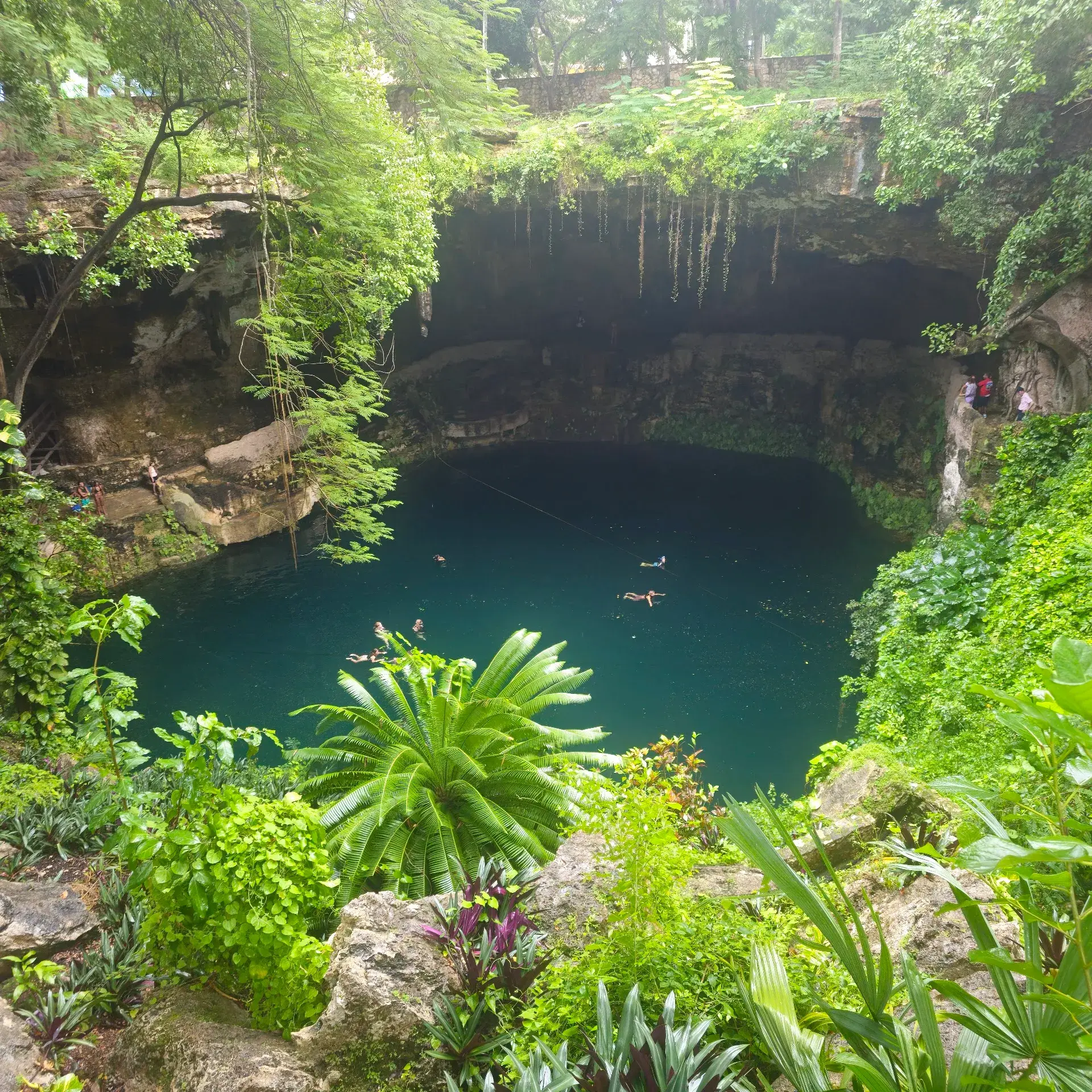
Peer down from the open-air rim of Cenote Zaci into the dramatic, cavernous sinkhole nestled right within the neighborhood. Hidden inside a residential city block lies the ancient water source that sustained the original Maya settlement of White Hawk. Connecting the central plaza and the Santa Ana neighborhood, it serves as Valladolid's primary natural symbol.
A Karst Sinkhole in the City
Unlike most famous Yucatán cenotes situated in remote jungles or sprawling haciendas, Cenote Zaci is a fully urban landmark. It is hidden in plain sight on a standard residential city block bounded by Calles 34, 36, 37, and 39. The site is located just three blocks northeast of Valladolid's central plaza.
Entering the cenote complex creates an immediate sensory break from the hot, bustling street grid. The atmosphere shifts into cool, humid air beneath an echoing rock cavern. The sounds of the city are replaced by the chirping and flapping of swallows and bats nesting high in the limestone ceiling.
Geological Features and Wildlife
Cenote Zaci is a massive semi-open karst sinkhole measuring roughly 40 to 45 meters across. A limestone vault ceiling rises 26 to 29 meters above the water surface, adorned with hanging stalactites formed by mineral-rich seepage. The open half of the roof allows natural light to pierce through, illuminating the deep turquoise and emerald water.
The pool is incredibly deep, ranging from 25 to 30 meters near the perimeter ledges down to approximately 100 meters in the deepest sections. Hanging vegetation and long vine roots drape into the water from the surface above. The fresh water is also home to clearly visible schools of dark, endemic freshwater catfish known as bagres.
Maya History and Folklore
The cenote preserves the indigenous identity of the pre-conquest settlement governed by the Cupul lineage. The Maya word Zaci translates to "White Hawk" or "White Sparrow Hawk." When Spanish conquistadors established the colonial city of Valladolid directly on top of the settlement in 1543, Cenote Zaci became the essential water source for the town due to the Yucatán Peninsula's lack of surface rivers.
For the Maya, the cenote held deep sacred importance as a spiritual portal to Xibalba, the underworld. The sinkhole is also steeped in regional folklore. One tradition recounts the tragic legend of Sac-Nicté ("White Flower") and Hul-Kin, lovers separated by a rivalry between local clans. According to the tale, Sac-Nicté tied a stone to her hair and threw herself into the deep waters, and a grief-stricken Hul-Kin followed her to join in death.
Modern Recreational Complex
Today, Cenote Zaci functions as a municipal tourist complex and recreational swimming site. An enclosed, stone-carved staircase and walking path circle the cavern interior. This pathway provides viewing areas along with access to swimming platforms and cliff-jumping points.
The adjoining parador turístico features an open-air regional restaurant, viewing decks, craft and souvenir vendor stalls, and lifejacket rentals. The facility operates daily, typically opening in the morning and closing in the late afternoon.
FAQ
How deep is Cenote Zaci?
The water depth ranges from roughly 25 to 30 meters near the perimeter ledges and plunges to approximately 100 meters in the deepest sections of the sinkhole.
Where is Cenote Zaci located?
Unlike remote jungle cenotes, Zaci is a fully urban sinkhole hidden on a residential city block. It is located about three blocks northeast of Valladolid's central plaza.
What does the name Zaci mean?
Zaci translates to "White Hawk" or "White Sparrow Hawk" in the Maya language. It was the name of the pre-Hispanic settlement that existed before the colonial city of Valladolid was established in 1543.
Discover Valladolid like never before
Dive into Valladolid hidden stories and secret spots with Ciceru interactive tours.
Explore tour
Audioguide
Quizzes
Maps
Solo
Couples
Groups & families
© Photo by Edgar Sanchez Pozo via Google Maps · Google Places